|
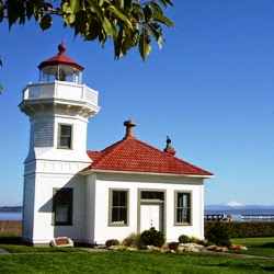
| Point Elliot Lighthouse - Mukilteo, WA |
One of my favorite local historic and scenic places is the Mukilteo lighthouse, Mukilteo is a small town located on the shores of Puget Sound about 25 miles north of Seattle and just south of Everett, Washington. It is the only lighthouse in Snohomish County and is the most accessible and easy to visit lighthouse in the greater Seattle area.
Built in 1905, it is on the National Register of Historic Places and also listed on Washington State's Heritage Register. It underwent a renovation in 1987 to return it as closely as possible to its original appearance, so it looks very much today like it did when it was built .
The ownership of the light station was transferred from the US Government to the city of Mukilteo in 2001 and it has become the town's main attraction and the centerpiece of the city park. An annual festival is held each September to celebrate this historic landmark. The lighthouse is still in use as a navigational aid and the US Coast Guard maintains the navigational equipment. including the signal light and foghorn.
The light station is open to the public every weekend from April through September. Admission is free, but donations are welcomed. Tours are offered by the local historical society and the site can also be used as a unique picturesque venue for weddings.
As you can see from the picture, the Mukilteo Lighthouse is also very photogenic little light station and even a mediocre photographer (like me!) can take some lovely photos.
Where is the Mukilteo Lighthouse?
Map and Driving Instructions to Mukilteo from Seattle:
From Interstate 5 roughly 22 miles north of Seattle, take Highway 526 west 3.5 miles to where it ends at Highway 525. Turn right on Highway 525 and follow it to the Whidbey Island Ferry Landing in Mukilteo.
The light station is to the left, just south of the ferry landing
 |
The Mukilteo Light Station
Quick Facts About the Mukilteo Lighthouse
- Built in 1905
- Lighthouse Tower is 38 Feet Tall
- Fourth Order Fresnel Lens
- Began Operation March 1, 1906
- White Light Flashes Every 5 Seconds
- Beacon is Visible for 12 Miles
The History of the Point Elliot Light Station
|
 |
| A Historical Photo of the Mukilteo Lighthouse - Photo credit US Coast Guard - Public Domain |
The Elliot Point light station was designed by architect C.W. Leick and construction began in 1905. This same plan was used to build two other Pacific coast lighthouses - the ones at Ediz Hook, Washington and Cape Arago, Oregon. The buildings were all built from wood and the total construction cost was approximately $27,000.
The tower is 38 feet tall and the station originally included a fog signal building, a keeper's house, an assistant keeper's house a well and pump house with a windmill to power the well pump.
The light has a fourth order Fresnel lens and a large fog horn pointed toward the sea. The station was completed and put into service in 1906. The white light from the beacon flashes every 5 seconds and is visible for up to 12 miles. The fog horn sounds for 3 seconds every 27 seconds and may be heard up to 8 miles away.
The original light was a kerosene lamp which required refueling and maintenance every 3 hours 24 hours a day. The oil light was replaced with an electric light bulb in 1927 and the original rotating Fresnel lens was replaced with a fixed lens.. The light bulb was replaced with a 150 watt halogen bulb in 1972. The fog horn was also replaced in the 1970s. The light and foghorn were both automated in 1979 and an automatic fog sensor was added in 1981.
Mukilteo Lighthouse Hours
A sign on the front gate provides information about the lighthouse including the hours it is open.
 |
Mukilteo Light Station Hours and Rules
|
Step Inside the Gate for a Tour
 |
| The Mukilteo Lighthouse |
The lighthouse and surrounding grounds are maintained by the city and volunteers from the
Mukilteo Historical society. Members of the historical society serve as hosts when the lighthouse is open to lead tours, answer questions and provide a wealth of information about the history of the area.
Photos and Exhibits Inside the Lighthouse
The old fog signal building contains a fascinating display of the history of the lighthouse.
 |
| Architechural Drawings of the Mukilteo Lighthouse |
Among the displays is a framed copy of some of the original architect drawings and plans.
A 1908 Photo of the Light Station
 |
Mukilteo Light Station, 1908
I took a picture of this old photo of the light station taken in 1908. The main keeper's house is to the right of the tower and attached fog station, and the assistant keeper's residence is to the left. The windmill has since been replaced by a garage which now houses more artifacts from the past.
|
What is a Fresnel Lens?
 |
| A Display About Fresnel Lenses at the Mukilteo Lighthouse |
The Fresnel (pronounced Fray-nell) lens was invented by Augustin-Jean Fresnel, a French physicist. I'm not a physicist, so my understanding is that the glass is shaped and arranged in such a way to create prisms which capture and bend the light to magnify and increase its intensity. The first Fresnel lens to be used in a lighthouse was installed in 1823 in a lighthouse in France. Fresnel lenses have many other uses including automobile headlights, theater spotlights, projector lights, camera optics, aviation lights or to focus sunlight to make more efficient solar panels.This display in the Mukilteo Lighthouse explains the "Order" of Fresnel lenses for lighthouses. Each lighthouse lens is categorized into an "Order" based on the size of the lens. It is on a scale of 1 through 6 with 1 being the largest, brightest lens and the 6th being the smallest and least bright.
The Mukilteo Lighthouse has a 4th Order lens which is not an exceptionally bright lens. Since the passages in Puget Sound are fairly narrow, the 12 mile range of the beacon is more than adequate to fulfill its purpose as an aid to navigation.
A Multi-bull's eyed fourth order Fresnel Lens
 |
| Multi-Bulls-eye 4th Order Fresnel Lens |
This gorgeous multi-bulls-eyed Fresnel Lens from the Desdemona Sands Lighthouse is a work of art! It was removed and replaced with a modern airport type beacon light and is now on display at the Mukilteo Lighthouse.
Climbing the Stairs to the Light Tower
 |
The Spiral Staircase to the Mukilteo Light Tower
|
After looking at all the displays, I started up the narrow, spiral staircase to the light tower. I couldn't really get a good photo to show how the stairway winds up the tower. The interpretive displays explained that the original kerosene lamp needed to be refueled every 3 hours. As I climbed the steep stairs, I thought of how many times the keepers made this climb each year to keep the beacon lit.
The Fresnel Lens
 |
Fourth Order Fresnel Lens - Mukilteo Lighthouse
|
This is a photo of my first glimpse of the Fresnel lens looking up from the stairwell.
 |
| Mukilteo Lighthouse Halogen Lightbulb |
Of course the days of the kerosene lamps are long gone, but it was still amazing to see what a tiny light powers the beacon. This 150 watt halogen bulb can be seen brightly for 12 miles with the magic of a Fresnel lens. It reminded me of pulling back the curtain and finding the Wizard of Oz.
The View From the Top of the Lighthouse Tower
 |
| A View of Puget Sound and a ferry from the Mukilteo Lighthouse |
This is the view from inside the tower facing approximately northwest toward Whidbey Island. A Washington State ferry was making one of its runs from the nearby ferry dock across Puget Sound to the island. Images of the light are mirrored on the window on both sides of the ferry.
Rainbows from the Fresnel Lens Prisms
 |
The Fresnel Lens From Outside
|
I took this photo from the outside deck of the tower looking in at the lens showing the rainbows from the prisms.
 |
| The Mukilteo Light |
After walking back outside to the grounds, I took this photo of the lighthouse tower as seen from below.
The Life of a Lighthouse Keeper
 |
| Mukilteo Lightkeepers House - Quarters A |
There are two keeper's houses at the Mukilteo light station. Quarters "A", as the coast guard called it, was the main keeper's residence. It is not open for tours, but this is the outside of the building facing the street away from the lighthouse and Puget Sound.
Mukilteo's First Lighthouse Keeper
 |
| Peter N. Christiansen, the first Mukilteo Lighthouse Keeper |
The first keeper who climbed the stairs to tend the light in the tower, was Peter N. Christiansen. He was born in Norway and served in the Merchant Marines and the U.S. Navy before becoming a lighthouse keeper. Before being assigned to the Mukilteo Lighthouse, P.N Christianson served as the assistant keeper at the Turn Point Lighthouse on Stuart Island in the San Juan Islands of Washington.
 |
| The Christiansen Family - First Residents of the Mukilteo Lighthouse |
Peter Christiansen served for almost 20 years as the first keeper of the Mukilteo lighthouse. He lived in the keepers house with his wife and four children until his sudden death from what was believed to be a heart attack in 1925. After his death, Peter Christiansen's wife, Theodine, assumed the duties as the second lighthouse keeper for 2 years. She was one of the first female lightkeepers. This plaque and photo of the Christiansen family is displayed near the entrance of Keeper's Quarters "A" facing Puget Sound.
 |
| Mukilteo Assistant Lightkeepers House - Quarters B |
The Assistant Keeper's Residence, (called Quarters B by the Coast Guard), now houses interpretive displays and a gift shop. This view is from near the water's edge of Puget Sound looking inland.
 |
| Lighthouse Keeper Uniform |
Inside the old Assistant Light Keepers Residence is an interesting museum about not only the history of the Mukilteo lighthouse, but also the history of lighthouses and the lighthouse service including a display of a light keepers uniform.
Lighthouse Souvenirs from the Gift Shop


The Mukilteo Lighthouse Festival
 |
| Mukilteo Lighthouse Festival Banner |
Each year in the 2nd weekend in September, the city of Mukilteo has a festival to celebrate the lighthouse.
- Mukilteo Lighthouse Festival - Celebrate By the Bay
The Mukilteo Lighthouse Festival Association - In 2004 Mukilteo service and community groups formed the Mukilteo Lighthouse Festival Association (MLFA) to carry on the spirit and tradition of the Annual Lighthouse Festival.
Planning a Visit to the Mukilteo Lighthouse?
If you are looking for lodging in Mukilteo, the
Mukilteo Silver Cloud Inn is within walking distance of the lighthouse. It is right on the waterfront overlooking Puget Sound and the ferry dock. There are several other hotels, but they are further away from the waterfront and lighthouse.
More Information About Lighthouses in Washington State
There are several organizations who are a great source of information about lighthouses in Washington State.